
We learned about changing pedestrian habits by analyzing iconic Holly Whyte films using sophisticated new tools. What can cities do next?
If you find yourself walking through a large, open space at the foot of an even larger office tower in midtown Manhattan, you are experiencing the legacy of the city's 1961 zoning code. At the time, as part of the first major rewrite since 1916, New York introduced its Privately Owned Public Space (POPS) program, which gave developers a density bonus for building a public plaza. In midtown Manhattan, builders could add 10 extra square feet of commercial space above ground for one foot of open space at ground level. In 2001, Harvard Design School Professor Jerold Kayden reported that the city had gotten 3.58 million square feet of these plazas in exchange for more than 16 million square feet of bonus floor area.
But were the new "bonus plazas" worthy successors of Europe's vital gathering spaces, such as Rome's Piazza Navona or Paris' Place Vendôme, or were developers just putting "paving around the base of their buildings," in Kayden's cutting words? In the 1970s, William "Holly" Whyte was determined to find out by filming how these public spaces are actually used. Fifty years later, as cameras blanket our cities and artificial intelligence enables the mass processing of visual data, we can revisit his analysis and discover how much public space, and our use of it, has changed. The preliminary answer from a study we've recently completed is: quite a lot.
By the time Whyte started his "Street Life Project" in 1970, he was already an urban legend. He had written a bestseller, "The Organization Man," that "defined corporate conformity and warned against its growth," and he had coined the term "groupthink." As an editor of Fortune magazine, he had recruited Jane Jacobs to write "Downtown is for People," which included the mantra, "the best way to plan for downtown is to see how people use it today." He also helped her get Rockefeller Foundation funding to transform that article into "The Death and Life of Great American Cities," a seminal text in 20th-century urbanism.
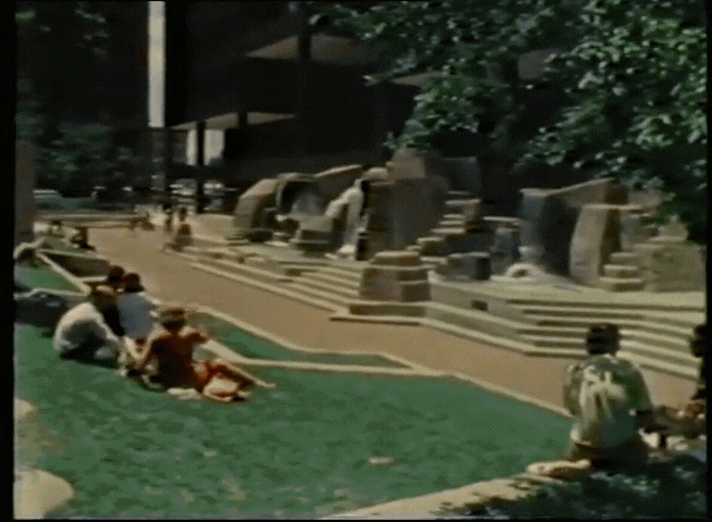
In 1969, when Whyte was working with the New York City Planning Commission, he decided to embrace Jacobs' mantra. To understand how New Yorkers actually used the new plazas, Whyte started filming with Super 8 cameras, recording time-lapse videos of public spaces across the city. He loved his movies, referring to his "first time-lapse record of the sun passing across the Seagram plaza" as "the most satisfying film I've ever seen" because it showed that "where there was sun, they sat; where there was none, they didn't." That correlation "vanished" as mild May was replaced by hotter June. He found that lovers were either oblivious or exhibitionistic, as "the most fervent embracing we've recorded on film has usually taken place in the most visible of locations." He documented the sublime and ridiculous ways we enjoy public spaces, and made keen observations, such as "what attracts people most, it would appear, is other people." (This is a finding that one of our recent papers replicated using quantitative data on crowding at the Louvre Museum in Paris.)
In 1979, Whyte turned his findings into a plan to save Bryant Park, which had "become the territory of dope dealers and muggers because it was relatively underused by other people." Whyte envisioned making the park a more seamless part of urban space by removing "the iron fences atop the walls" and the "shrubbery", and by improving "the visual access from the steps on Avenue of the Americas." He also wanted "ramps for the handicapped," new steps into the park and to its upper terrace, and a rehabilitated fountain and restrooms. Another Whyte protégé, Dan Biederman, would become the president of the Bryant Park Foundation and use Whyte's vision to transform the park into one of New York's most perfect public places.
Jane Jacobs looked at what she saw around her. She was no flaneur, but she did have the skill that Franz Hessel ascribes to a flaneur, who "reads the street, and human faces, displays, window dressings, café terraces, trains, cars, and trees become letters that yield the words, sentences, and pages of a book that is always new." Holly Whyte was able to observe vastly more images of urban life by using the technology of his day: high-quality cameras and film stock. Fifty years later, we can take another leap forward in urban observation by using artificial intelligence to process the visual data that is being generated all around us. The journalistic insights of Jacobs and Whyte can grow into a statistical social science that enables cities to make data-driven decisions that will make parks, plazas and sidewalks more welcoming for everyone.
To turn Whyte's footage into usable data, he needed an army of researchers, which is why his book thanks no less than seven foundations and the personal support of Laurance Rockefeller. His costly and laborious process explains why Whyte's methods were only rarely replicated, despite the obvious value in observing how people actually use urban spaces. More than a decade ago, Scott Fahlman famously called artificial intelligence an "idiot savant," which was not yet a "human-like intelligence, in all its generality, flexibility and resilience" but "successful in producing super-human performance in a number of narrow, disconnected problem domains." But Whyte didn't need research assistants to create masterpieces, he needed them to process huge amounts of images and videos and to perform simple, repetitive tasks like counting the number of women and men. That is a problem tailor-made for idiot savant-AI, which is also leaps and bounds smarter than it was when Fahlman made his observation.
Together with our colleagues, we trained an AI model to analyze William Whyte's original footage and compare it with footage of the same public spaces made by sociologist Keith Hampton in the late 2000s. Whyte's team took hundreds of hours to process their film. Even Hampton, working just 15 ago, was stuck with the same manual methodology. Once we had trained a deep learning model, the process took minutes, which makes it possible to imagine measuring street life almost anywhere.
We found that people in the 21st century stand around less and walk 15% faster, perhaps because their time is more valuable — or because they just think it is.
We limited ourselves to four sites, because we wanted to be able to connect with Whyte's original movies, both in homage to him and in order to explore how street behavior has changed over time. Happily, a corner outside of Bryant Park was one of the four areas, and so were the steps of the Metropolitan Museum. Outside of New York, we have Boston's busy Downtown Crossing area and Chestnut Street in Philadelphia.
What has changed? We found that people in the 21st century stand around less and walk 15% faster, perhaps because their time is more valuable — or because they just think it is. The biggest change occurred in Downtown Crossing, which morphed from having almost the most people lingering in 1980 to having the least 30 years later. Perhaps we should have expected that, given Boston's transformation from a sleepy, declining town to a capital of the information age.
Boston's increasing busyness may also explain why we observe fewer pairs of people strolling in Downtown Crossing in 2010 than we did in 1980. That pattern is reversed near Bryant Park, where there are more people walking together. We think that reflects the success of Whyte's vision for the park and Biederman's implementation of that vision. While Downtown Crossing has become less of a destination and more of a thoroughfare, Bryant Park has become more of a place for couples to go.
Finally, we observe a decided downward shift in the number of people who meet and then walk together at all four sites. The shift is again most dramatic at Downtown Crossing, but the decline in dyads forming on the steps of the Metropolitan is also quite large. Since we don't know if people knew each other beforehand, we can't say if this shift reflects a decline in spontaneous connections or a reduction in the number of prearranged meetings at urban focal points.
Now we can use AI and films of street life to take Jacobs to scale. Cities throughout the world can learn how to better manage the public spaces they have, and to design better ones for the future.
To use AI on the vast quantities of film being taken today, we would need to sort out some privacy issues. While taking pictures of street life is perfectly legal, there is something uncomfortable about letting AI have access to all that information. One reasonable precaution might be to anonymize the images by blurring out people's faces, which is what would be required in the European Union.
But if we iron out such wrinkles, there are few remaining limits to what we can learn about how people interact in public spaces: How dense various neighborhood sidewalks are at different times, how often people walk with dogs and push strollers, whether New Yorkers in fact have a penchant to be so impatient as they pass slow walkers like speeders on the highway.
William Whyte used his technology-assisted eyes on New York to implement Jane Jacobs' vision of planning cities based on how people actually use them. Now we can use AI and films of street life to take Jacobs' vision to scale. Cities throughout the world can learn how to improve management of the public spaces they have, and to design better ones for the future. They can calculate where to put benches, or which impeded sightlines cause cars to hit bicyclists. They can explore which areas are more conducive to human interaction and to that quintessential urban function — providing a harbor "for lovers and friends." The application of quantitative tools to a long-standing urban planning tradition championed in the 1970s by William Whyte could help us design better public spaces. Paradoxically, AI can make our cities more humane.


